Kwamtili Estate, Tanzania
Supporting a community's cocoa know-how and protecting a virgin forest.
Mapping
Kwamtili Estate in the Eastern Usambara Mountains, Tanzania, is today a somewhat reduced (1150 hectare) version of an enormous estate that was created when Tanganyika as it was then known was a German colony.
Today it forms part of one of the largest forested mountain regions in the entire Usambara Mountains. The region is compact and comprises Kwamtili Estate in the north with the adjacent Kwagumi, Segoma and Bomba Ridge Forest Reserves to the south (see the Kwamtili map).
The estate remains the only known producer in Africa (and perhaps globally) of criollo cocoa that is grown from grafted (and therefore cloned) seedlings. Criollo cocoa is highly sought after, especially the premium grades produced by Kwamtili Estate (criollo accounts for at most 5% of global cocoa production).
Both the cultivation of criollo cocoa and the grafting of cloned cocoa are therefore likely to be unique in Africa. Introduced to Kwamtili over 80 years ago, they also represent an enormous potential and a remarkable heritage .
Know-how concerning the cultivation and grafting of criollo cocoa belongs to former estate workers. Many live in the local community close to Kwamtili Estate, notably in the village of Kwamtili. Some 15 families from the community are organised as an association that has a licence to maintain, process and sell Kwamtili's cocoa in exchange for providing security.
Security is needed because a large part of the estate comprises virgin forest that is adjacent to the Kwamgumi Forest Reserve , a globally recognised biodiversity hotspot. A major concern is the loss of forest cover by encroachment and illegal logging (a report of 2018 is being updated).
With the support of the owners of Kwamtili Estate Ltd., the ongoing programme is to support the Kwamtili community in association with the UsitawiNetwork whose aim is to protect Kwamtili Forest and to ensure that the immediate surrounding area occupied by the remainder of Kwamtili Estate is secure.
This somewhat outdated summary of Kwamtili Estate's activities, operations and location was prepared in 2014.
Kwamtili Estate in northern Tanzania is situated in the foothills of the Eastern Usambara Mountains in what is referred to by environmentalists as the Eastern Arc Conservation Hotspot.
Kwamtili Estate is located in northern Tanzania.
The Google Maps cordinates of the estate's cocoa factory (clearly visible in satellite photos) are "-4.922781,38.733802". Enter this in the Google Maps search field.
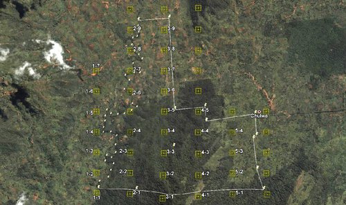
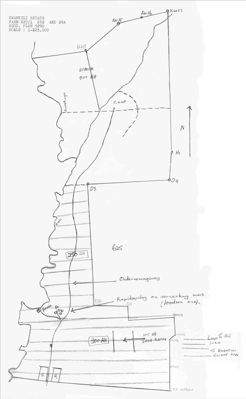
Kwamtili Estate boundary. Forest covers a major part of the estate (2012 image).
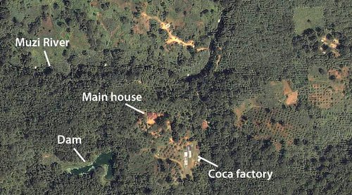
Aerial photo of main house, cocoa factory and dam.
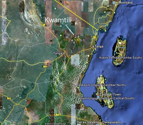
Usambara Mountain region. Kwamtili is located about 5 kilometres to the right of the top end of the green area on the left marked as the East Usambara Mountains.
The Usambara's (see map) form a major part of the ancient Eastern Arc mountain chain that stretches in a broken crescent from the Taita hills in southern Kenya down to Morogoro and the southern highlands in Tanzania. The mountains are estimated to be at least 100 million years old and the rocks forming them may be as much as 600 million years old. They are home to an exceptional assortment of plants and animals and represent one of the highest degrees of biodiversity on the African continent. A relatively recent (2015) biodiversity report confirms these findings, see PDF.
The importance of the Eastern Usambara Mountains has been summarised as follows by the Tanzania Forest Conservation Group:
"The forests of the East Usambaras are among the most important for biodiversity conservation in Africa. Research indicates that if the forests become too fragmented and isolated then a number of the species known only to exist from this area will become globally extinct. Since 2004, with support from the Ministry of Foreign Affairs of the Government of Finland, World Wildlife Fund - Finland has been leading a partnership project (East Usambara Forest Landscape Restoration (EUFLR)) within 28 villages in Muheza and Mkinga Districts that aims at reducing the loss of globally important biodiversity, improve livelihoods and restore a multi-functional landscape in the area. The project is implemented in the field by the Tanzania Forest Conservation Group (TFCG) with technical support from World Wildlife Fund Tanzania Programme Office."
Dating from pre-world war times, Kwamtili Estate originally covered over 5000 hectares, of which some 1150 ha were planted with kapok, derris, some cocoa, and rubber. After the 1st World War the estate became neglected. In the 1950's the market for kapok and derris declined.
Prior to these developments, the area must have been covered in forest with a large population of Melitia exelsa trees, locally known as mvule. There is, in fact, still evidence of logging and sawing activities that must have formed part of the economic activities during the estate's heyday.
Efforts are underway to revive the estate based on another company acquiring the assets. This aspect is not discussed.
Today, the estate covers 1150 ha and can be described in three sections:
- about 770 ha of Kwachawa Mountain forest, virtually conserved, with a respectable population of small animals, birds and, seasonally, butterflies;
- 350 ha of the old cocoa plantation, which was planted with exotic trees for shade for the cocoa crop. This section is of questionable value both economically and environmentally.
- 30 ha of productive cocoa plantation.
Although not making a profit, the estate remains about the only one of its kind in Tanzania today. With cocoa planted under a canopy of old natural forest, it is home for a number of bird and animal species.
To all intents and purposes, Kwamtili Estate is no longer operating as a commercial enterprise. Efforts are underway to transform the estate into a conservation and eco-tourism area that can be used as the basis for community projects and long-term conservation of the indigenous forest while maintaining a viable cocoa operation.
The main aspects of the estate are described below. Those wishing to visit the estate should contact Kwamtili Estate's majority shareholder, Ms Latifa Fielder (streetno11 .at. gmail.com ).
Kwamtili Estate
Location and access
Kwamtili Estate is a cocoa plantation situated in Mkinga District, Tanga Region, in north-eastern Tanzania, about 50 km from the coast of the Indian Ocean. It is situated at the foot of the Usambara Mountains Complex and has an area of 1150 ha, which includes 770 ha of forest. Most of this forest covers the Kwachawa Mountain, which itself is approximately 680 ha.
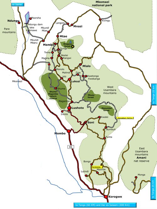
The estate is accessible from Tanga by an earth road which connects Maramba to Tanga, some 50 km away. There are regular mini-buses and buses from Maramba to both Tanga and Muheza.
From within the estate, there are tracks that connect it to the Amani Nature Reserve (see Tanzania Forest Services Agency description). These tracks are currently not motorable, but potentially they can be upgraded to rural road status.
An earth road, largely unmaintained but of good quality, that connects Kwamtili to Maramba, Muheza and Tanga passes through the estate.
Goods and crops are transported from surrounding villages by trucks. Historically, in the wet season, when the rural roads are particularly bad, the trucks would be assisted by tractors. Generally speaking, this is no longer the case since many roads have been properly surfaced in recent years.
The village of Chula lies on the eastern boundary of the estate and can be used as a reference for Google maps. The Google image in the figure above shows the boundaries of the estate.
The estate is isolated with a part of the southern boundary adjoining the Kwamgumi Forest Reserve. For the other boundaries, the western boundary has a well-defined natural boundary (the Muzi River, a seasonal stream in a valley) and part of the eastern boundary is effectively defined by a densely forested seasonal watercourse. But there are significant parts of the boundaries that are not well defined. Areas adjacent to these boundaries are largely sharecropped. All boundaries are marked with concrete plinths.
The area surrounding the estate is impoverished and mainly occupied by small subsistence-level farms. However, Kwamtili, a sizeable village, has grown up on the other side of the Muzi River that defines the estate's western boudary.
The UsitawiNetwork has supported community development projects to encourage cocoa growing and other aspects of the estate's activities.
The East Usambara Mountains are almost entirely within Muheza District in Tanga region, apart from some smaller parts in the west that fall in Korogwe District. The mountains rise to an altitude of 1506 m at Mount Nilo. The population in 2015 was 101,767 people distributed across 61 villages in the area. Outside of forest reserves, most of the forest has been cleared for farmland, apart from in the proposed Derema Forest Reserve and some other areas proposed as Village Forest Reserves (for example, the proposed Derema Forest Corridor). Some forest also remains in private hands, as is the case with Kwamtili Estate.
The Eastern Arc Mountains Conservation Endowment Fund website gives some information about the East Usumbara mountains, www.easternarc.or.tz/mountain/east-usambara/
The Eastern Arc Mountains Conservation Fund strategic plan (PDF) for 2021-30 includes creating a proposed Eastern Arc Mountains World Heritage Site. While the proposed Site does not include the chain of mountains (Kwachawa - Gonja -Lukindo - Segome: see map) of which Kwamtili forms a part, the Nilo - Amani corridor that is a major component of the proposed Site lies only five kilometres to the west of Kwamtli.
A brief history
In modern times, the owner of the company that owned Kwamtili Estate died and was laid to rest within the farm in in 1958. Management of the estate was left to his wife. In 1961, roughly one-half of the estate was sold to Kwamtili Estate Ltd. (the map taken from the sale agreement shows the area comprising the lower half of Kwamtili Estate that was sold to create today's Kamtili Estate).
Subsequently, Kwamtili Estate Ltd. was run from a town office in Tanga. The majority shareholder initiated some major agricultural projects in the 1990's and sold shares in 2000 to the current majority shareholder, who manages the estate. The other main shareholder and a member of the Kwamtili Estate Ltd board is the son of the previous majority shareholder. Several other shareholders no longer survive. The company, which is in the process of confirming its share register, currently enjoys a seven-year Title to Occupy for Kwamtili Estate.
Several proposals have been made to merge the Kwamtili area with neighbouring forests reserves, see CMEAMF 2010 proposal, for example PDF. Most of these ignored the fact that the Kwamtili area is leased to Kwamtili Estate Ltd, that operates the area, including the forested area, commercially.
Climate
The climate in the Kwamtili area is predominantly governed by the atmospheric circulation of the inter-tropical convergence zone, a low pressure zone with adjacent high pressure zones that oscillate north and south annually resulting in a monsoon climate with a bi-modal rainfall regime.
Thus, the climate can be classified as a tropical bi-modal savannah climate with a difference of less than 5°C between the mean monthly temperature of the warmest (February, March: maximum temperature = 31°C) and the coldest months (July, August: maximum temperature = 27°C). The mean annual rainfall is about 1500 mm, falling mainly in April/May and in October/November.
Water resources
As mentioned above, the estate is bounded by the Muzi River to the west. This river is perennial, although the flow decreases in the dry season. Several seasonal streams flow from the Kwachawa Mountain into the central part of the estate. A dam has been built in the centre of the estate and is able to support cocoa processing and a limited watering of young plants most of the year.
In general therefore, there is a lack of permanent, bilharzia-free water. A proposal has been made to bring water across the valley beyond the western boundary from the Eastern Usumbara Mountains to the estate. This scheme seems unrealistic given that villages would take off water and leave little if any pressure available for reaching the estate.
There are apparently no permanent springs on the estate, and while the dam provides significant storage, it is seasonal and can only be used for agriculture and cocoa processing.
A borehole near the main house is unserviceable and records are apparently unavailable. So a programme of tests bores as part of a water management plan is probably needed to evaluate potential permanent borehole resources.
However, a limited seasonal use of water runoff with storage in tanks may be sufficient for say tourist activities part of the year.
Soils
The soil conditions at the estate vary considerably over short distances. Most soils of the area are ferruginous, deep, sandy clays and clays, moderately acid, but fairly well provided with nutrients. Many soils however are gravely and/or shallow which are crucial factors for root development and moisture storage. Five different soil series have been recognised, each with a number of phases for slope, effective depth and presence of gravel occurring in a complex pattern over short distances.
About 35% or 170 ha of the estate has a high gravel content, resulting in only marginal potential for cultivation. Deep and very deep soils cover 80 ha and 100 ha of the estate respectively, of these areas however, 84 ha have soils with drainage problems or are subject to regular flooding.
The overall results of the land evaluation in terms of the physical suitability indicates that the Kwamtili Estate in general has a limited potential for the cultivation of cocoa. Highly to moderately suitable land for cocoa covers only approximately 30% of the estate. Moreover, the strong variability of the soil conditions over short distances and the consequent complexity of the physical suitability of the estate lands within each block strongly affect the management of the estate and how the cocoa is planted (it is planted in relatively small areas scattered throughout the areas most suited for cocoa).
Most of this information comes from an old Dutch survey, the estate having seen some investment in the 1980's by the Dutch development bank FMO that used a mortage on the estate as collateral. The mortage has since been relinquished.
Present vegetation and land use
The present vegetation in the area can be described generally as mixed forest. On the Kwachawa Mountain, the vegetation is predominantly of indigenous species. In the lower areas, there are patches of planted forest species, which were introduced as shade trees for cocoa.
Parts of the estate are planted with cocoa, cashew and small-scale garden crops. On the periphery of the estate and surrounding areas, regular cultivation for annual subsistence crops such as maize and beans is the main land use.
This cultivation is permitted under agreements with the estate owner in exchange for a defined quantity of produce.
Cocoa
In the 1960's an area of about 85 ha was planted with cocoa. Today, about 35,000 of the cocoa trees that were planted on this area are still surviving. In 2002, an additional 19 ha were planted with cocoa, with 5 ha planted in 2004 and 2 ha planted in 2007. Since the formation of the Kwamtili community group, the planting of cocoa by the group with the estate owner's permission has been irregular and amounts to about 5 ha.
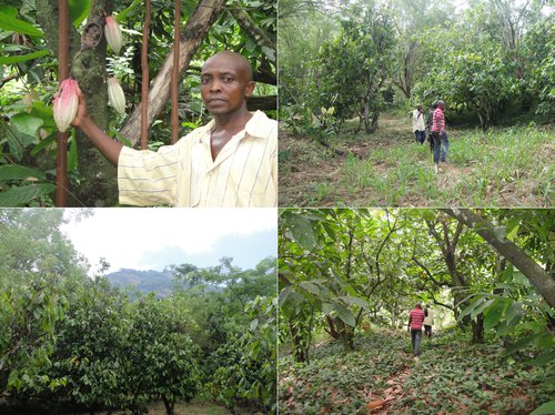
The photos show a cocoa pod held by the estate's administrator, a view of Kwachawa Mountain with cocoa trees in the foreground, and two views of cocoa areas.
Infrastructure
The estate infrastructure includes a main residential house that is reasonably livable, various stores (all in working order) and a cocoa processing factor in working order.
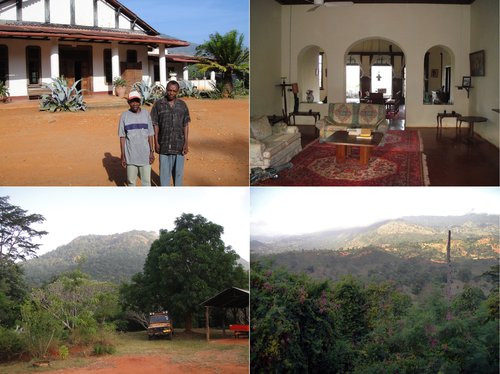
The photos show the view from the house across to the Eastern Usambara Mountains and the view behind the house to Kwachawa Mountain.
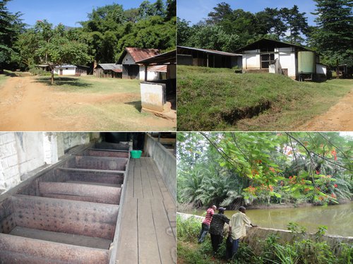
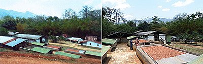
These photos show the factory site with the main factory and outhouses, the cocoa washing trays and the dam.
These photos from 1988 show the factory in operation.
Ecotourism
Kwamtili Estate's interest in ecotourism was taken up by the East Usambara Forest Landscape Restoration Project in 2008 (see summary of the several phases of the project). The estate aims to become a conservation and eco-tourism area. Its location forms a major break in the Eastern Usambara natural forest.
The objective of the transformation into a conservation and eco-tourism area is to assist in defragmentation efforts of the Eastern Usambara forest.
The East Usambara Restoration Project (EURP) is currently a new five-year project (2022-2026) implemented by WWF and funded by WWF-Switzerland. The project aims "to restore and conserve East Usambara sub-montane, lowland and coastal forests for local community’s livelihoods and wildlife".
A Kwamtili Estate marketing brochure was released in 2015, see PDF.
For further information, please contact Peter Boswell, peter@peterboswell.com
Updated 18 January 2025