Kwamtili historical mapping
See:
- Kwamtili blog for details
- Kwamtili map
- Kwamtili mapping - deforestation
Kwamtili today
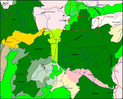
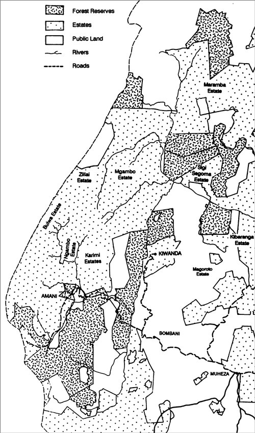
Kwamtili Estate is located at the northern tip of the chain of mountains that cover the adjacent Kwamgumi, Segoma and Bamba Ridge forest reserves in Tanzania's East Usambara Mountains. The map from a World Wildlife Fund for Nature (WWF) 2006 report Key forest gaps improved landscape planning and restoration in the East Usambara Mountains shows the Kwamtili Esate boundary (in red) and the three forest reserves.
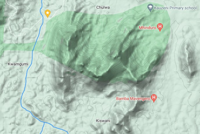
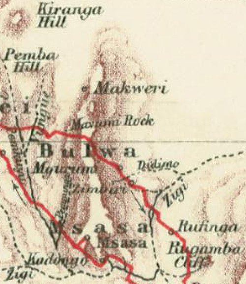
This map from Google Maps shows the various mountain peaks that make up the three forest reserves. It also shows the Sigi River passing south of the reserves before turning sharply southwards where it is joined by the Musi (formerly Muzi) River. The Musi starts above Kwamtili Estate (marked on the map with a yellow marker) and constitutes the estate's western boundary before descending along the western foot of the chain of mountains before reaching the Sigi.
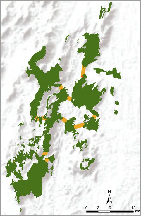
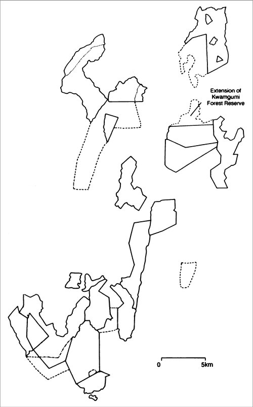
Maps of the Usambara Mountain's forests reserves and forested areas (determined very conservatively) show that the Kwamgumi, Segoma, Bamba Ridge and Kwamtili forests make up a large, compact and dense forested area which is one of the largest in the Usambaras. Kwamtili is marked in red on the forest map. The yellow areas are proposed ecological corridors that would link up forest reserves.
Recognition that Kwamtili represents an integral part of an extremely important and large forested area has led to various interpretations. For example, in 1989 the Tanzania government together with the IUCN published a report Forest Conservation in the East Usambara Mountains which included a map showing that according to the Ministry of Lands, Housing and Urban Development in 1973/4, Kwamtili Estate did not exist. Instead, it is shown as incorporated into Maramba Estate despite Kwamtili Estate Ltd holding a Title of Occupancy.
Fortunately, Kwamtili Estate is now sometimes shown as a proposed extension to the Kwamgumi Forest Reserve, as is also the case in 1989 IUCN report.
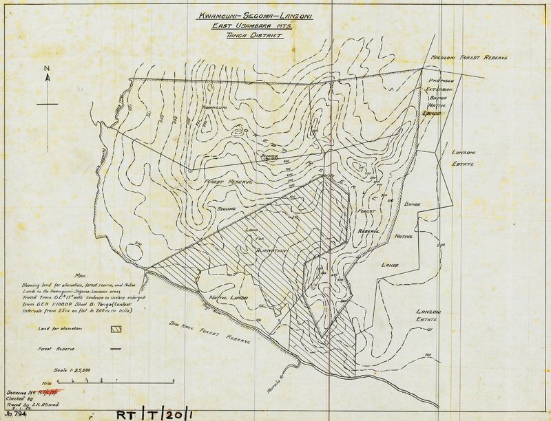
In fact the proposal to incorporate Kwamtili Estate is relatively recent compared to other proposals to extend the Kwamgumi and Segoma forest reserves. For example, a map traced in 1962 describing the proposal to incorporate what is know known as the Bamba Ridge Forest Reserve to the east as well as a large part of the Sisi Segoma Estate to the south does not mention Kwamtili Estate to the north.
It is interesting to note that the 1973/4 government intepretation of land holdings includes not only the Sisi Segoma Estate but also several other estates. These estates mainly have there origins in colonial times, notably while Tanganyika was a German colony. Tracing these origins with regard to Kwamtili Estate is the focus of this text.
Before looking backwards it is perhaps useful to point out that a map of Kwamtili Estate and its surroundings as they exist today is maintained.
Colonial-era maps
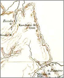
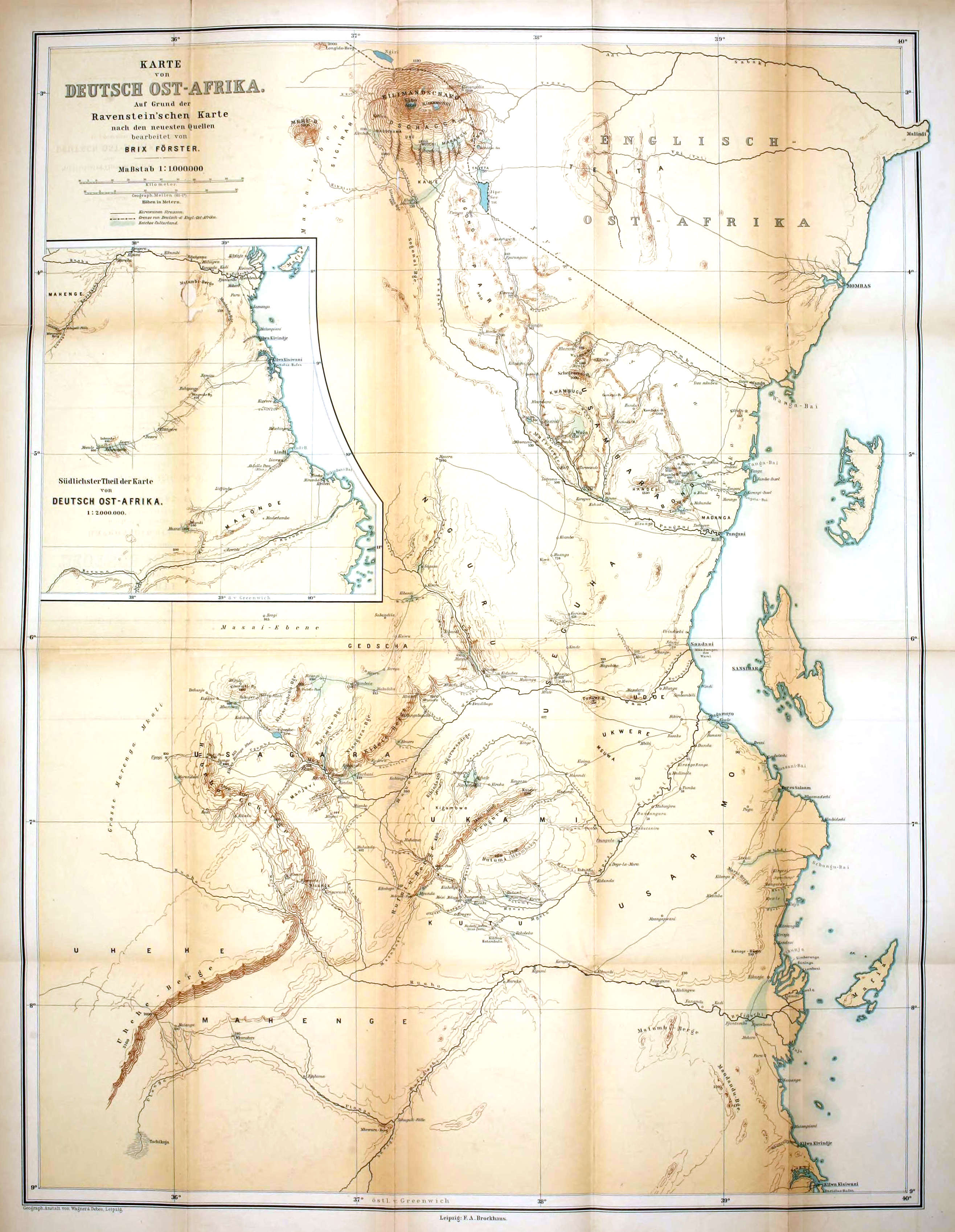
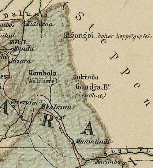
It appears that the earliest formally reported mapping of Kwamtili was the 1: 1000000 "Deutsch Ost-Afrika" map by Brix Förster that was published in Leipzig by F.A. Brockhaus in the early 1880's. The map is available in the Project Gutenberg e-book of Deutsch-Ostafrika - Geographie und Geschichte der Colonie by Brix Förster. As explained earlier, the image of the map's top right shows the Musi River (in black) forking as it passes south of the Segoma chain of mountains. Kwamtili is located where "Kombola" is marked. The chain of mountain peaks that make up the Kwamtili - Kwamgumi - Segoma - Bamba Ridge forest are drawn as a narrow mountain range.
At about the same time, Keith Johnston made a report to the Royal Geographic Society titled Notes on a Trip from Zanzibar to Usambara made in 1879 which included a map of the Usambaras. However, while the map seems to have identified the fork in the Musi River, there is no reference to the nearby Kwamtili - Kwamgumi - Segoma - Bamba Ridge mountain range.
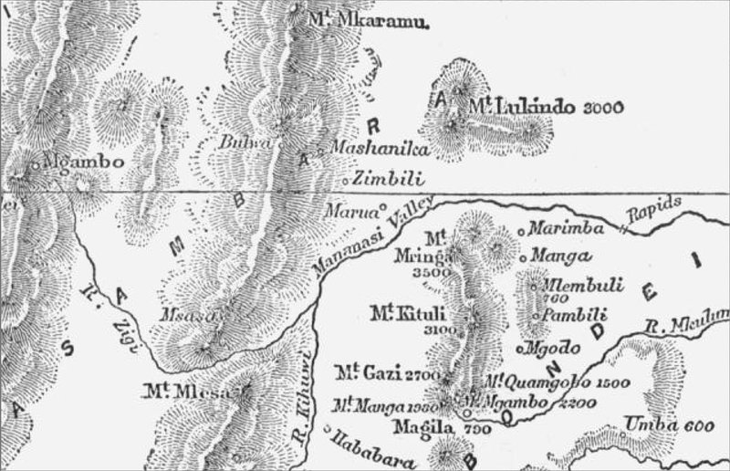
Johnston noted in his report that J.P. Farler, a missionary living at Magila, had described The Usumbara Country in East Africa in a 1878 report to the Royal Geographic Society. The Kwamtili - Kwamgumi - Segoma - Bamba Ridge mountain range is marked on Farler's map as Mount Lukindo.
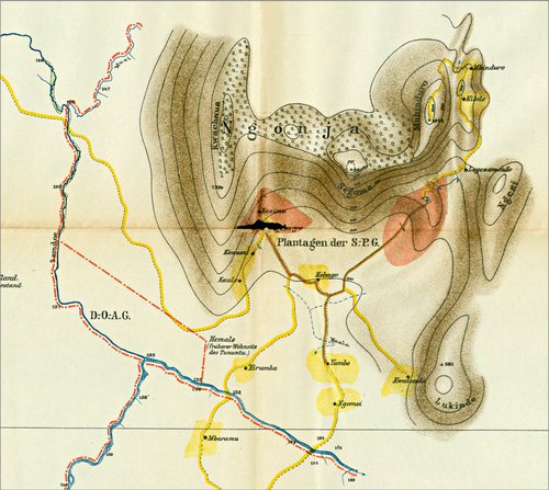
A few years later (1988-9), Oscar Baumann's maps embelished somewhat the Förster map, and added some clarification with regard to Kwamtili. The "original" (presumably final) 1888 map (also here) of the Baumann-Meyer study of the Usambara's (summarised here) shows three peaks in the Kwamtili - Kwamgumi - Segoma - Bamba Ridge mountain range. Kwatschana corresponds to Kwachawa, the the name given today to the peak that lies on the Kwamtili Estate - Kwamgumi Forest Reserve boundary. Mountain peaks called Gondja and Lukindo are also marked.
Baumann's provisional map (also available here) (apparently published in 1889) of the 1888 map is in fact clearer. It shows a point halfway along what is believed to be the Kwamtili - Kwamgumi - Segoma - Bamba Ridge mountain range marked as Lukindo and the mountain range itself is clearly split into two parts corresponding to the Kwamtili - Kwamgumi - Segoma - Bamba Ridge mountain range (called Gondja) in the south and the Mtai mountain range and forest range to the north of Kwamtili. In Baumann's 1888 map, Mtai is simply marked as a locality, along with Kigungoi, renamed to today's Kigongoi in the provisional 1888 map.
An interesting aspect of both the provisional and original Baumann maps are the two different routes marked in the Kwamtili region (the routes are marked in red). For now it is unclear how Baumann's routes relate to the established trade route or routes from Pangani on the coast opposite the island of Pemba to the interior.
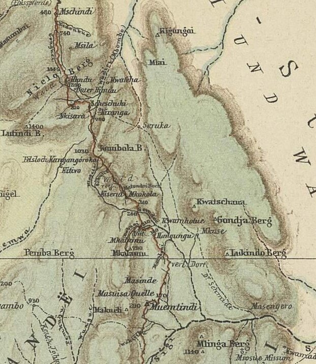
To the west of the Kwamtili - Kwamgumi - Segoma - Bamba Ridge mountain range lies the the mountain range that makes up the Somdoe and Kambai forest reserves. The reserves are separated by a narrow gap above which lies the village of Kizerui (called Kiseria in the Baumann 1888 maps) on the edge of what is today the Nilo Forest Reserve. Moving north from Kizerui there is an area of fairly flat, partially wooded land in the range of mountains that run north to south along the middle of the Nilo reserve. It would appear that routes north from Kizerui to Kizara (called Kisara in the Baumann 1888 maps) passed through this area, although tracks are not evident today in satellite images.
In the case of the provisional map, Baumann approached from the south-east along the Musi River before branching off westwards near a location called Mkalamu to Kizerui and moving northwards to Kizara. In the original map he approached Kiserui more from the south. Since rivers and the location of mountain peaks are marked differently it is difficult to establish the routes taken. A preliminary assessment is that both routes climbed out of the Musi River valley opposite Kwamtili close to today's Kambai village before reaching Kizerui. However, this needs checking as the mountain terrain between Kambai and Kizerui is very broken up.
Baumann's 1891 book Usambara und seine Nachbargebiete builds upon the provisional and final 1888 maps in giving further details of the region around Kwamtili. A map makes clear the separation between what is now known as Kwachawa Mountain on the Kwamtili Estate - Kwamgumi Forest Reserve boundary and the Mtai mountains to the north. Unfortunately, a high resolution image appears to be unavailable. The now disused track (see the Kwamtili map) running northwards between the Kwamtili - Kwamgumi - Segoma - Bamba Ridge mountain range and the Musi River through Kwamtili Estate and on to Maramba is shown.
Baumann's final (1894) original map of Deutsch-Ostafrika für das Deutsche-Antisklaverei-Komite gives a clearer view of the geography around Kwamtili Estate. The gap between Kwamtili Estate - Kwamgumi Forest Reserve area and the Mtai mountain range is clearly drawn, together with the road through Kwamtili to Maramba. The area north of Kwamtili Estate is once again called Gordja. Mountain peaks on the eastern side of the Kwamtili - Kwamgumi - Segoma - Bamba Ridge mountain range appear to be called Tathulua and Magomboni. They probably correspond to the hilly forested areas known today as Mlungui (a Forest Reserve) and the forest south of Maramba and Matemboni (Magomboni?).
The 1894 map includes Baumann's routes of 1888-90 and 1892-93 as well as routes taken by G.A. Fischer in 1883 onwards. With regard to the routes that cross the mountain range to the west of Kwamtili, it would appear that Kizerui is once again crucial since it is the location where Baumann's routes cross near a place marked Langusa about 6 km west of the Musi River. For the south-eastern route into Kizeru, Baumann probably passed through Kambai. The route from Kizerui on to Kizara through dense forest is far from clear, apart from knowing that it probably meant passing through the gap in the mountain range above Kizeru. On the other hand , the north-eastern route out of Kizeru passing through Kwamtili Estate to Maramba north is well established, even to this day.
To help relate Baumann's maps to today, Baumann's 1894 map has been provisionally georeferenced (see the Kwamtili map).
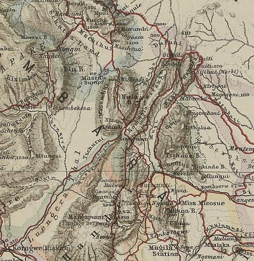
More detail about the area around Kwamtili Estate emerged in H. Böhler's Ost-Usambara 1897-1899 map. The main peak on the eastern side of the Kwamtili - Kwamgumi - Segoma - Bamba Ridge area is called Kwachaua which corresponds to today's Kwachawa. The forested highland area is called Ngonga (Gonja?) and its southern region lying to the south of the Segoma Mountain s called Segoma. Böhler's map is of particular interest because it marks the Sigi-Pflanzungs Gesellschaft (S-PG) estate in Segoma and the Deutsch-Ostafrikanischen Gesellschaft (D-O-AG) estate. The S-PG estate, marked on the 1974 ministry map as the Sigi Segoma Estate, existed until quite recently as the United Sigi Segoma Estate Ltd. Together with the D-O-AG estate, it is now largely incorporated into the Segoma Forest Reserve that borders the Kwamgumi Forest Reserve to the north.
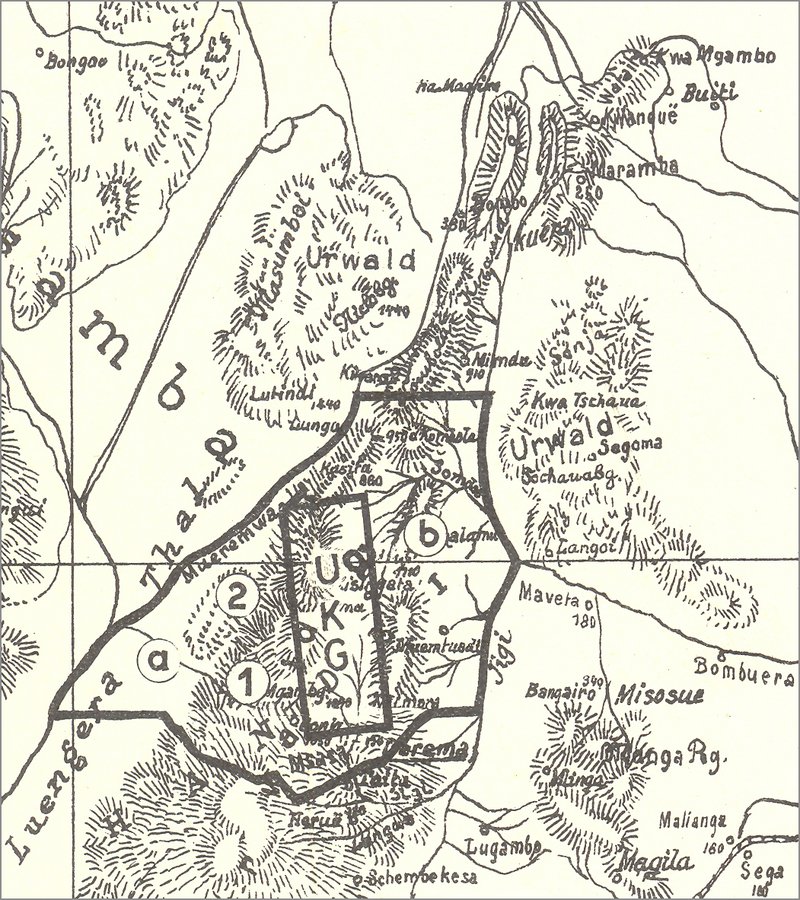
While estates dating from colonial times will be discussed elsewhere, a 1919 map showing the Usambara Kaffeebau Gesellschaft (UKG) estate is not without interest. Segoma and the Kwachawa Mountain on the Kwamtili Estate - Kwamgumi Forest Reserve border are marked (Kwachawa as Kwa Tschaua). The area north of Kwamtili Estate variously called Gonja or Ngonja is marked as Sonja. The map shows that the UKG estate as part of the larger Rheinische Handeï-Plantagen-Gesellschaft (RHPG) estate. The RHPG (the larger outlined area in the map) had the Musi River is its northeastern boundary. It appears that the estate reached as far north as the Kwamtili Estate - Kwamgumi Forest Reserve boundary.
10 February 2023